 English
  Français
  Español
 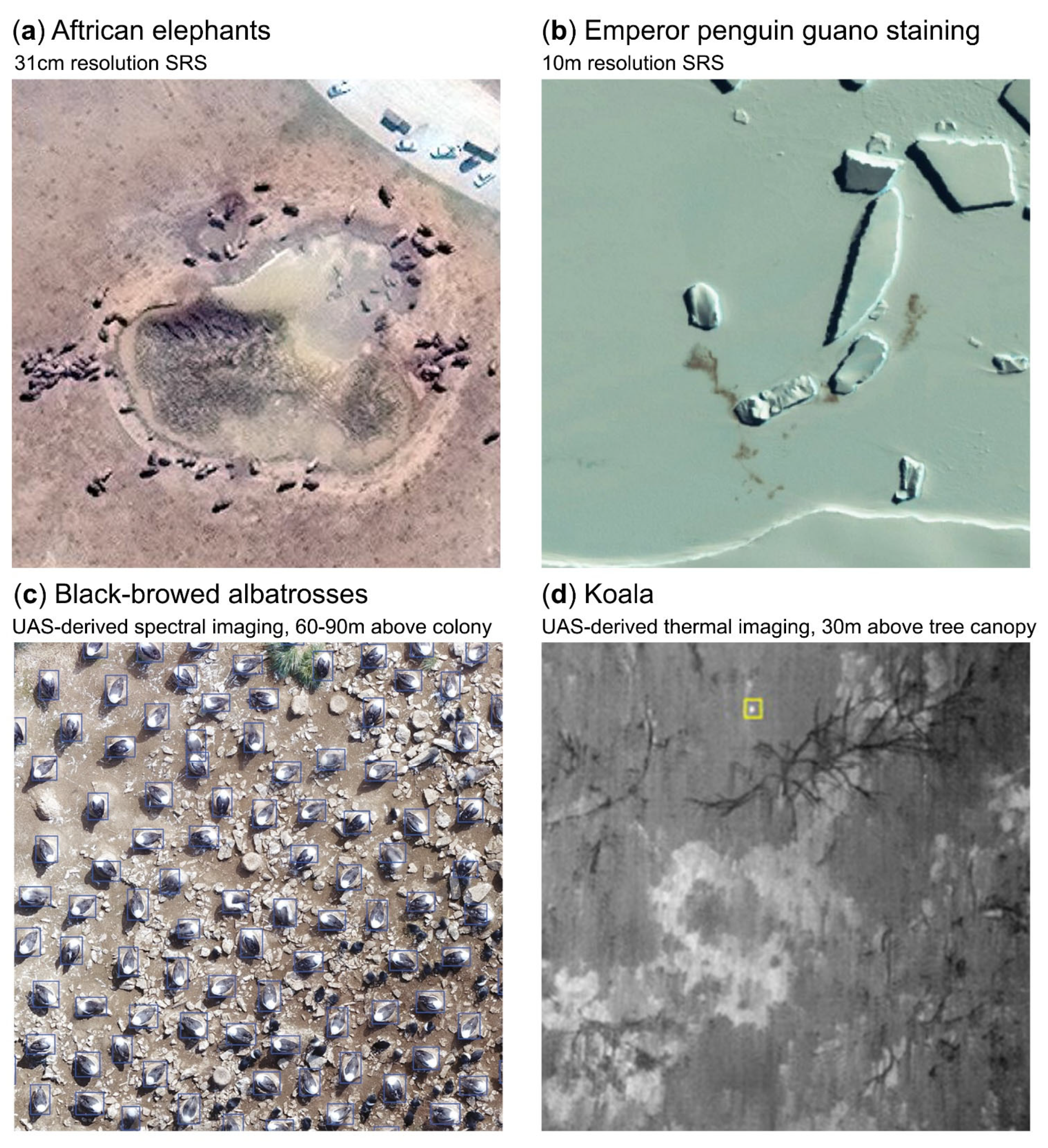 Figure 1 from the paper shows examples of wildlife detected in satellite and unmanned aircraft system (UAS) imagery. (a) VHR satellites can be used to count individual animals provided that they meet key detection criteria: in an open habitat, of suitable size, and of contrasting colour to the background. For instance, African elephants are visible in open savannahs using 31 cm resolution WorldView-3 imagery [14]. (b) Indirect counts can be performed for species which are not directly detectable; for example, colony sizes of emperor penguins can be estimated from the colony area or the extent of guano staining using 10 m resolution Sentinel-2 satellite imagery [15]. (c) Spectral imagery collected by UAS is typically of higher resolution than that of satellite sensors, enabling counts of smaller animals, such as black-browed albatrosses, in open habitats [16]. (d) For species in closed-cover habitats, for instance, koalas in tree canopy (shown in yellow box), thermal cameras mounted on UAS can aid detection [17]. All panels are cropped versions of the originals and are reproduced under CC BY 4.0 licenses.
Marie R. G. Attard (British Antarctic Survey, Natural Environment Research Council, Cambridge, UK) and colleagues have published open access in the journal, Remote Sensing, Census Guidelines using drones or satellites.
The paper, which was discussed at the 7th Meeting of the Albatross and Petrel Agreement’s Population and Conservation Status Working Group, provides an introduction for wildlife biologists and managers relatively new to the field on how to implement remote-sensing techniques (satellite and unoccupied aircraft systems) for counting large vertebrates on land, including marine predators that return to land to breed, haul out or roost, to encourage wider application of these technological solutions.
A link to the article is also available on the ACAP website via the Conservation Guidelines page.
The abstract follows:
“Although many medium-to-large terrestrial vertebrates are still counted by ground or aerial surveys, remote-sensing technologies and image analysis have developed rapidly in recent decades, offering improved accuracy and repeatability, lower costs, speed, expanded spatial coverage and increased potential for public involvement. This review provides an introduction for wildlife biologists and managers relatively new to the field on how to implement remote-sensing techniques (satellite and unoccupied aircraft systems) for counting large vertebrates on land, including marine predators that return to land to breed, haul out or roost, to encourage wider application of these technological solutions. We outline the entire process, including the selection of the most appropriate technology, indicative costs, procedures for image acquisition and processing, observer training and annotation, automation, and citizen science campaigns. The review considers both the potential and the challenges associated with different approaches to remote surveys of vertebrates and outlines promising avenues for future research and method development.”
Reference:
Attard, M.R.G., Phillips, R.A., Bowler, E., Clarke, P.J., Cubaynes, H., Johnston, D.W., Fretwell, P.T. 2024. Review of Satellite Remote Sensing and Unoccupied Aircraft Systems for Counting Wildlife on Land. Remote Sensing https://doi.org/10.3390/rs16040627
28 March 2024