 Español
  English
  Français
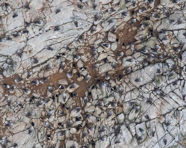
Salvin’s Albatrosses on Proclamation Island, Bounty Islands, from a drone photograph in the report
Graham Parker & Kalinka Rexer-Huber (Parker Conservation, Dunedin, New Zealand) have produced a final report for the Conservation Service Programme (CSP) of the New Zealand Department of Conservation on the use of drone photographs to count breeding albatrosses at the sub-Antarctic Bounty Islands.
A CSP summary separate to the report follows:
“Salvin’s albatross Thalassarche salvini are a Nationally Critical seabird endemic to New Zealand. They breed at two sites, predominantly at the Bounty Islands, and are one of the New Zealand seabird species most at risk from fisheries bycatch. The population status at the Bounty Islands is poorly known due to logistical difficulties in conducting research at this remote location, and differences and inherent uncertainties in methods previously used to assess population status. By extrapolating densities from one island, population sizes of 76,000 and 31,000 pairs across the group were estimated in 1978 and 1997, respectively. Method differences, including in how densities and areas were estimated, led to targeted repeat censuses of marked areas that over time gave worrying data on trends (30% decline in breeding pairs between 1997 and 2011). Repeat counts for trend assessment, however, need to be complemented by whole-population size estimates because a small count site may or may not remain representative of changes in the whole population over time.
Because many of the islands are inaccessible to boat-based landings, aerial photographs appear to be the best way to estimate population numbers across the whole Bounty Island group and assess trends over time. Aerial photographs taken from fixed-wing aircraft have been used to count Salvin’s albatross in the past. Estimates ranged between 42,800 and 60,400 birds, although not all birds counted in photographs will have been breeding. However, surveys involving aeroplane charter or helicopters are logistically demanding and expensive, so other methods for aerial surveys are being explored. Population monitoring by drones hold promise as an alternative way to obtain aerial photographs suitable for estimating albatross numbers at reduced effort and cost. Also known as unmanned aerial vehicles (UAV), drones are increasingly used for seabird population assessment and monitoring worldwide. In the New Zealand subantarctic, drones have been used successfully for a range of wildlife monitoring at the Antipodes and Auckland Islands. Relative to piloted aerial surveys, drone surveys have low operational costs, simple logistical requirements, and are relatively low risk for operators, while providing data that are systematic, repeatable, and accurate. Some constraints are similar, particularly the impact of wind, rain, and haze on image acquisition. As with any survey method drones also have limitations, notably in battery life and potential for wildlife disturbance.
Effects on animals are becoming better documented as drone use for wildlife surveys becomes more common. To date, drones have been used at the Bounty Islands primarily to assess the potential for wildlife disturbance. The islands are densely populated with fur seals Arctocephalus forsteri, erect-crested penguins Eudyptes sclateri and smaller seabirds as well as the Salvin’s albatrosses, so the potential for disturbance by drones was assessed carefully. Disturbance of animals on the ground or in the air was minimal provided the drone was flown with due caution (avoiding seal clusters near launch site, flight height assessed relative to flying bird density but not below 20m flight height).
We discuss the implications of data quality in this report for future potential drone-based estimates of the population size of Salvin’s albatross at the Bounty Islands, and provide recommendations for how best to deal with some of the uncertainties inherent in aerial count data. To assess if drone-image counts are comparable with existing data (photo counts from aircraft, ground counts), we then do whole-island counts of Salvin’s albatross on all islands that have had drone overflight (Proclamation, Spider, Tunnel and Ranfurly Islands). We document baseline drone counts, compare results to those from other methods, and discuss the relative utility of survey methods.”
Reference:
Parker, G.C. & Rexer-Huber, K. 2020. Drone-based Salvin’s albatross population assessment: feasibility at the Bounty Islands. Final report to Department of Conservation, Marine Species and Threats July 2020. Dunedin: Parker Conservation. 18 pp.
John Cooper, ACAP Information Officer, 19 October 2020